Early explorers, like Columbus, Magellan and Lewis and Clark, used maps and made their own charts to help find their way in new and unexplored worlds. In these exercises, your students will follow these explorers' example by creating and interpreting maps of Mars. Students will explore the desert world of Mars, a planet that is in some ways similar to Earth, yet full of unexpected differences. When the first spacecraft flew past Mars in 1965 (Mariner 4), many people were surprised when the Mariner camera revealed ancient, Moon-like, cratered regions. Scientists were further surprised in 1972 when Mariner 9 discovered landscapes of volcanoes, canyons and dry riverbeds.
Mars is a planet of extreme scales. Although it is smaller than the Earth (its diameter is about 6781 kilometers; Earth's is 12,756 kilometer), it has the largest volcanoes on any planet. The largest, Olympus Mons, is nearly as tall as four Mt. Everests, and is so wide that it would completely cover the state of Arizona. The Grand Canyon of Mars, Valles Marineris, would stretch from Los Angeles to New York, while the water that once flowed down the dry martian riverbeds would have made the Mississippi flood of 1993 look like a small stream.
USGS
Earth's Grand Canyon would look like a small ditch next to Mars' Valles Marineris, the immense canyon system named after the Mariner 9 spacecraft that discovered it. Valles Marineris is about 5,000 kilometer long, about as wide as the continental United State. The canyon system is about 500 kilometer wide and as deep as 6.5 kilometer
Several questions can help you and your students imagine what it would be like to stand on the surface of Mars. Could you see across Valles Marineris? If you stood at the foot of Olympus Mons, could you see its summit, some 27 kilometer high and several hundred kilometer away? If you went instead to the lowest elevations on Mars, would you find water? Where might you find a good place to land a spacecraft and begin to explore this new world? The robotic Viking Landers 91 and 20 were set down gently on the surface of Mars in 1976. What kinds of features were the researchers looking for when they chose the landing sites?
Your students will begin to answer these and other questions by studying maps and photographs that indicate the topology and location of landforms on the martian surface. Our goal is to give the students a familiarity with Mars' landscape. By interpreting maps and analyzing images of Mars, students can come to a greater understanding about the martian landscape.
In these activities, students assume the roles of cartographers and explorers. They receive, assemble and analyze data to understand Mars' landscape. We include two Mercator projection maps of the surface of Mars based on Mariner 9 data. Scientists used these maps to plan the Viking missions. Duplicate these to distribute to your students. For lower grade level, we recommend that you review map scale, contour intervals, latitude and longitude before beginning the activities.
The prime meridian, or zero longitude, on Mars passes through an impact crater called Airy, located about five degrees south of the equator. Airy is Mars' equivalent to Greenwich, England, through which Earth's prime meridian passes. The crater is named after nineteenth century British astronomer Sir George Bidell Airy, who, during his tenure as director of Greenwich Observatory, installed the transit instrument used to define the zero degree meridian on Earth. The crater has been pitted by several impacts, and a small crater on its floor is the precise point through which zero longitude is measured. This smaller crater is named Airy-0, the "0" representing zero-degree longitude. In this kit, we indicate the crater location on the Mercator maps and a Mariner 9 image of Mars' surface
Topographic mapping of Mars is very similar to methods used to map Earth. The exception is that Mars has no seas or ocean, hence it has no actual sea level. How do cartographers determine martian "sea level?" Mars scientists refer to the sea level as the topograpic datum. This datum is the elevation designated as zero. For Mars, the zero elevation is defined by the mean martian radius, 3,382.9 kilometer, and the atmospheric pressure is 6.1 millibars (6.1 thousandths of the Earth's atmosphere). If you were standing on the martian surface and the center of the planet were 3,382.9 kilometer beneath your feet, then you would be standing at 0 kilometer elevation. Likewise, if the surface depth to the center of the planet were 3,407.9 kilometer, you would be at an elevation of 25 kilometer. You'd probably be standing on Olympus Mons.
To determine the elevations from which we made the topographic maps enclosed in this kit, scientists combined the 1972 Mariner 9 mission data with Earth-based radar. The ultraviolet spectrometer instrument on the Mariner measured the intensity of ultraviolet light scattered between the orbiting spacecraft and the surface. By analyzing the amount of atmosphere under the Mariner, scientists measured elevations to an accuracy of 0.6 kilometers. The higher the atmospheric pressure, the lower the elevation (when compensated for temperature). The lowest elevation is in the huge impact crater, Hellas Planitia. This is also the location of the highest atmospheric pressure on Mars.
Mars' topography is generally higher in the cratered southern hemisphere than in the northern hemisphere, where there are mostly low-lying plains. A major feature that extends from the martian equator into the northern hemisphere is the Tharsis Plateau. This 6,000-kilometer-wide plateau rises to 10 kilometers at its highest elevation. Three huge shield volcanoes (large volcanoes with slopes no steeper than 10 degrees) extend across the western highlands. West of these three volcanoes is the largest volcano on Mars, Olympus Mons. Although its elevation exceeds 27 kilometers, it generally has less than a 10 degree slope; the great width between the contour lines indicates this gentle slope. The steepest slope is not on a volcano but on the walls of Valles Marineris, a large rift valley on the southern hemisphere. Along the steep escarpments of this valley, the contour lines appear to merge.
In the southern hemisphere, the average elevation is between three to four kilometers. In the northern hemisphere, the average elevation is about zero kilometers. Curiously, however, the lowest elevation is in the southern hemisphere's highlands, more than four kilometers deep in the impact crater Hellas Planitia. Conversely, the highest elevation is in the northern hemisphere, on Olympus Mons.
The purpose of the eastern and western Mars maps is to impress on students visually how much lower the plains of the northern hemisphere are than the southern hemisphere. You might need to help student groups interpret the color-coded USGS topographic map by placing it next to their topographic maps. The blue and black colors extend to -4 kilometers, while the yellow and white colors are 5 kilometers above the topographic datum. On this map, the three Tharsis volcanoes and Olympus Mons are easy to find, with their bright yellow collars. The Tharsis Plateau is the very high, white to red area in the western hemisphere. Extending from the Tharsis Plateau is Valles Marineris, outlined in white for identification. Most of the dots or small circular features are impact craters (blue on black in the equatorial region and red on yellow near Hellas Planitia).
The mini-poster "Martian Volcanoes" includes a Viking image of the western edge of the Tharsis Plateau with three large shield volcanoes. Circular Olympus Mons is in the upper left corner. You might want to direct student attention to the enormous size of this volcano. It is as wide as the state of Arizona. Ascraeus Mons is the large volcano on the right, with Pavonis Mons below it. To introduce students to visualizing surface relief, we place a color topographic map of these volcanoes below the image. Each kilometer in elevation has been assigned a color value. The color key appears beside the image. Elevations range from lower than the topographic datum (0 kilometers) to higher than 26 kilometers.

NASA/JPL
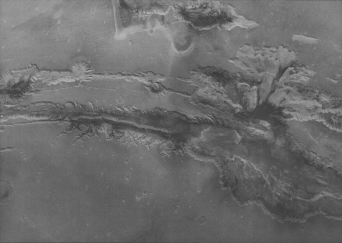
The dry, rocky landscape of Mars: Two of Viking 2's high-resolution scans were combined to create this image of Utopia Planitia.
Planetary spacecraft send data back in the form of radio waves, electromagnetic waves of a particular frequency. In the Viking mission, these signals had a wavelength of about four centimeters and are close to the same value as the wavelengths in a microwave oven. To actually send this data, scientists modulate these radio waves. That is, scientists change the frequency of the wave slightly to send binary patterns of ones and zeros. These patterns are turned into numbers that represent the data from the different instruments on a spacecraft. For example, like all computer pictures, an image from a spacecraft is made of numbers that represent the brightness of each small spot, or pixel (picture element), on the image. The pixels are arranged in a rectangular grid. The image of Mars taken with the Mars Observer Camera contains about 90,000 such numbers. These numbers were sent to Earth and converted into pixels to form the image on the back cover of this book.
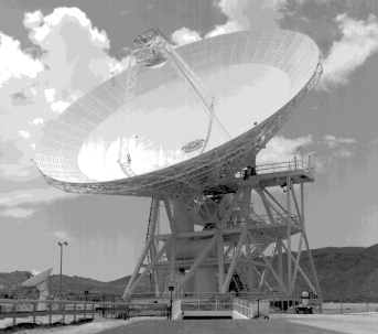
Planetary images return to NASA's Deep Space Network (DSN), a global system of three radio antennas-Goldstone, California; Canberra, Australia; and Robledo de Chavela (near Madrid), Spain. The Network Operations Control Center is located at the Jet Propulsion Laboratory in Pasadena, California. From there, scientists monitor, control and coordinate planetary mission operations. This communication network is distributed around Earth, so, as our planet rotates, scientists can be in continuous communication with spacecraft. Although spacecraft are engineered to operate somewhat independently in the far reaches of space, they depend on the Earth-based DSN for the uplinked commands and downlinked reception of data. During some Mars missions, data downloaded through DSN is transmitted to the Jet Propulsion Laboratory, where it is stored on computers and later accessed by mission investigators. DSN provides the communication circuits that link DSN complexes to the control center and to the remote flight-project centers that manage and operate the spacecraft.
NASA/JPL
This antenna is part of the Goldstone Deep Space Network Station.
Display the enclosed MarsLink Poster and the mini-posters. You might want to display the mini-posters of Crater Airy and martian volcanoes with a string that leads from the feature to their locations on the topographic map of Mars.
A topographic map of your community can be distributed to students so they can locate their homes or school as part of the lesson. You can purchase these maps from the USGS, map vendors listed in the phone book, or sports and hiking supply stores.
You can also display "An Explorer's Guide to Mars" map (available from The Planetary Society), a colorful and helpful guide to Mars' landscape.
We recommend that students develop MarsLink portfolios so that you and they can assess their growth in knowledge, skills and attitude. MarsLink guides the development of this portfolio.
The MarsLink writing team will include a variety of activities and experiences for students in each activity kit. Students can decide which activities or images they would like to include in their portfolio. For middle school students, teachers should share the selection responsibility. High school students can select what they think represents their best work and favorite activities. Materials included should be dated and a table of contents maintained. With this portfolio, students and teachers will be able to evaluate their achievements-gaining knowledge, modifying attitudes and developing skills. This will help promote interest in learning throughout MarsLink, and periodic portfolio reviews will provide you with a tool for judging individual student growth.

NASA/JPL
On July 20, 1976, the Viking 1 lander took this photograph, the first ever taken on the surface of Mars. This picture shows us a typical image of Mars' cold, arid surface -- rocks and a fine grain sediment. One of the lander's footpads appears in the lower right. The vertical linear bands are the results of data transmission errors. The large rock in the center is about 10 centimeters (four inches) across and shows three rough sides. Many of the small rocks in the foreground are flat with angular sides. We obtained most of the data and images used for MarsLink from Viking and earlier Mariner missions